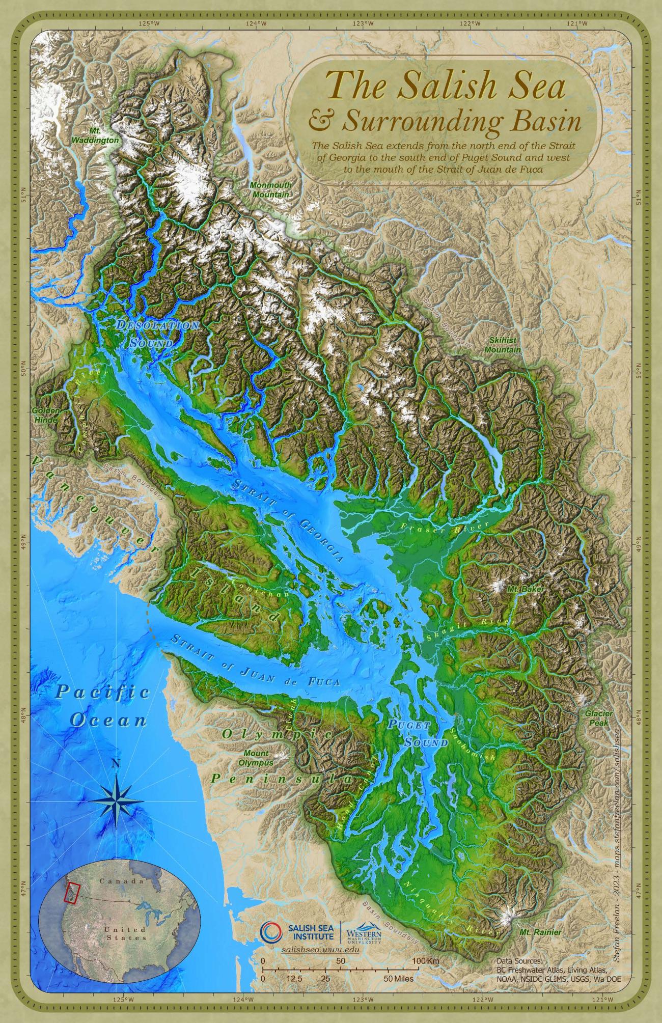
The Salish Sea & Surrounding Basin
For prior versions visit: maps.stefanfreelan.com/salishsea.
The Salish Sea extends from the north end of the Strait of Georgia and Desolation Sound to the south end of Puget Sound and west to the mouth of the Strait of Juan de Fuca including the inland marine waters of southern British Columbia, Canada and northern Washington, USA. These separately named bodies of water form a single estuarine ecosystem. Freshwater input gives the Salish Sea its status as an estuary and the immense volume of water from the Fraser River drives the circulation of the inland sea.1 Formally adopted by Canada, USA, and Washington (2009) and British Columbia (2010),2 'The Salish Sea' as a name for these waters has been embraced by residents on both sides of the border for years including the Coast Salish Gathering (the alliance of Coast Salish Tribal and First Nation leaders).
The Salish Sea is connected to the Pacific Ocean primarily via the Strait of Juan de Fuca (with relatively little tidal influence from the north through Johnstone Strait) and is largely contained by Vancouver Island and the Olympic Peninsula. In addition to the Gulf and San Juan Islands the watershed contains the lower Fraser River Delta and the Puget Lowlands as well as Discovery Pass, Butte Inlet,3 Jervis Inlet, Howe Sound, Deception Pass, Hood Canal and the Tacoma Narrows.
Over 9 million people live within the drainage basin of the Salish Sea,4 including the cities of Vancouver, Seattle, Victoria, Olympia, Nanaimo, Bellingham, Everett, Port Angeles, Port Townsend and Tacoma. In addition to the human population, the ecosystem is home to over 200 different species of fish, over 100 different species of bird, 20 different species of marine mammal and over 3,000 different species of invertebrates.1 5 6
Salish Sea Details:
The surface area of the Salish Sea (saltwater) is approximately 18,000 sq. km. (or about 7,000 sq miles).7 Within the Salish Sea there are hundreds of islands (or even thousands, depending upon one’s definition of an ‘island’). The surrounding Salish Sea drainage basin (not counting the upper Fraser River watershed) includes approximately 110,000 sq km (or about 42,000 sq miles).
| Approximate Maximum Water Depths8 9 |
Approximate Saltwater Surface Area |
Saltwater Surface Area % of Salish Sea |
|
|---|---|---|---|
| Strait of Georgia (including N. Gulf Islands) |
410 meters | 6,400 sq. kilometers | 36% |
| Strait of Juan de Fuca | 250 meters | 4,400 sq. kilometers | 24% |
| Desolation Sound | 600 meters | 1,100 sq. kilometers | 6% |
| Puget Sound | 280 meters | 2,500 sq. kilometers | 14% |
| Other BC (Discovery Passage, Jervis Inlet, Howe Sound, S. Gulf Islands | 660 meters (Jervis Inlet) | 2,000 sq. kilometers | 11% |
| Other WA (Haro Strait, Rosario Strait, San Juan Islands, Bellingham Bay, Padilla Bay) | 300 meters (Haro Strait) | 1,600 sq. kilometers | 9% |
Name Details:
The name Salish Sea is not a historical term for the inland waters of British Columbia and Washington State.10 It was proposed by marine biologist Bert Webber in 1988. Dr. Webber and others recognized the need for a single geographic term that encompassed the entire ecosystem, spanning across the international border. Having a common name to identify the entire area calls attention to the trans-border commonality of water, air, wildlife and history. Rather than being a replacement for any of the existing names, the designation Salish Sea is an overlay, or umbrella, term which includes and unites the established and familiar names of the various water and land bodies (the Strait of Georgia, Strait of Juan de Fuca, Puget Sound, Gulf Islands, San Juan Islands, etc.). The name also pays tribute to the Coast Salish peoples who have inhabited the area for over 10,000 years.
Map Details:
This map of the Salish Sea was originally created as part of the 2009 Salish Sea naming campaign. It was revised and updated with better data in 2023. The maps were produced using a Geographic Information System (GIS) and publically available spatial datasets for elevation, bathymetry and hydrology. Variations of color on the map are based on elevation (not actual land cover). Colors were chosen to mimic the ‘feel’ of the Pacific coast landscape (greens for the lowlands, white for the mountain peaks). In addition a 'hillshade' effect has been created, casting a virtual 'shadow' across the landscape to better depict the topography as if one is seeing a 3-dimensional shaded relief model. Similar color gradations are applied to the bathymetric data, again with a shadow effect applied as a 'floorshade' (i.e. a 'hill'-shade for the ocean floor).
The Salish Sea basin boundary was derived from the elevation data following the peaks and ridges. Areas outside the surrounding basin have been masked (shaded) by a semi-transparent overlay to highlight the geographic area draining directly into the Salish Sea. Note that the entire upper Fraser River watershed is technically a part of the Salish Sea drainage area. For this map, the Salish Sea basin has been defined as just that area draining directly to the ocean, including only the lower Fraser River watershed. Thus the 'basin boundary' depicted on the map is not the same as the full Salish Sea watershed.
It is unusual for a map of this type to exclude the cities, roads and borders that have been created by humans. Instead, this map focuses on the Salish Sea and its surrounding region, defined not by political jurisdictions but by the geography of the water and land. As such, the text labels on the main map are likewise used only for the natural features defining the Salish Sea.
Cartography: Stefan Freelan, 2023 (original 2009)
Elevation and Bathymetry Data: USGS, Living Atlas, NOAA
Software: ESRI's ArcGIS Pro 3.x
Additional Data: BC Freshwater Atlas, NSIDC GLIMS, Wa DNR, WA, DOE
Footnotes
1State of the Salish Sea Report, Kathryn Sobocinski, et. al., Ginny Broadhurst and Natalie Baloy, Contributing Editors, Salish Sea Institute, 2021
2The Washington State Board of Geographic Names and The Province of British Columbia Geographical Names Office
3 Some definitions of the Salish Sea exclude Discovery Pass and Bute Inlet at the northern boundary
4 GIS calculations derived from US Census Bureau data and Canadian Census statistics and the Salish Sea Atlas, Aquila Flower, et. al., 2020
5Species of Concern within the Georgia Basin Puget Sound Marine Ecosystem: Changes from 2002 to 2006, Nicholas A. Brown and Joseph K. Gaydos, The SeaDoc Society, 2007
6Puget Sound Georgia Basin Ecosystem, US EPA website, 2009
7 GIS area calculations derived from SRTM (CGIAR-CSI) elevation data
8Water Properties in the Straits of Georgia and Juan de Fuca, Emilie Davenne and Diane Masson, Institute of Ocean Sciences, Sidney, BC, Canada, 2001
( http://www.pac.dfo-mpo.gc.ca/sci/osap/projects/straitofgeorgia/JdFG_e.pdf )
9 The Puget Sound Model Summary , John H. Lincoln, University of Washington, Department of Oceanography, Seattle, Wa.
10 Other names that have been proposed throughout history include the Gulf of Georgia (1870's), the Western Sea (1950's), and the Ish River Sound (1980's)